Taiwan Day 6 - The Sun & a Museum
Full picture set of the day here: Flickr set or slideshow.
I've pretty much figured out my work groove. It goes something like this. Wake up early, work for a few hours and help out with the end of the day back on EST. Then go for a ride, come home, then work maybe 2 more hours and help the 2nd shift guy with any issues he's having. Then we do lunch and go out, run errands, do stuff, etc. If we're home I may hop online, or if I see emails when I'm out I'll reply. At the end of the day I'll throw in a few more hours unless I get them in during the day. I'm trying to cross-train this guy in London but he doesn't get in until 5:00 pm Taiwan time. So far, this has worked well. My PC in NY stopped responding to remote attempts but we got that worked out, mostly.
Told Nat I was going on a bit of a longer ride this morning, for no other reason than I want to start sprinkling in more time in the saddle so I can go out and explore more stuff. Most of the ride I had done before, but there was a bit of an extension at the end which I wanted to loop because it leads me to the base of 3 different epic rides I'd like to try to do before we leave - Pear Mountain, TaiPing Mountain, and the north cross-island highway. So it was a sort of scouting mission for those.
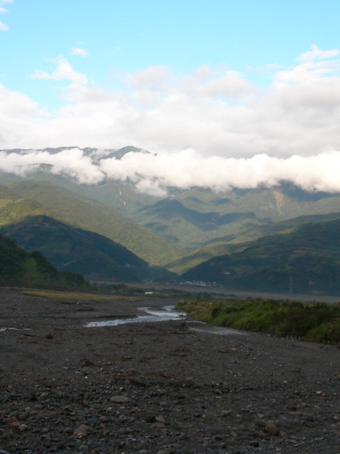
I preloaded breakfast and set out with the roads still wet from the rain overnight. The sun was supposed to show its face today but I was doubtful until I saw some blue sky in the distance, straight ahead. For the first 10 miles to the base of the hills, I was looking at a view straight out of a post card. Unfortunately I didn't have the good camera (I use the "old" digital to throw in my pocket) so the quality isn't really that great. But this gives you an idea:
Shortly after I headed off the main drag and onto an "industrial road" which is what a lot of these lesser roads are called. This one was well-paved and wide, so it wasn't a quarry road or anything like that. It went up quickly but not for very long, and it wasn't the leg-burner that the previous 2 days had been. I wanted today to be a tamer ride, so I scouted out a route with less vertical. No holy grail on this ride, at least not in theory. Imagine my surprise when I got to the top and saw this:
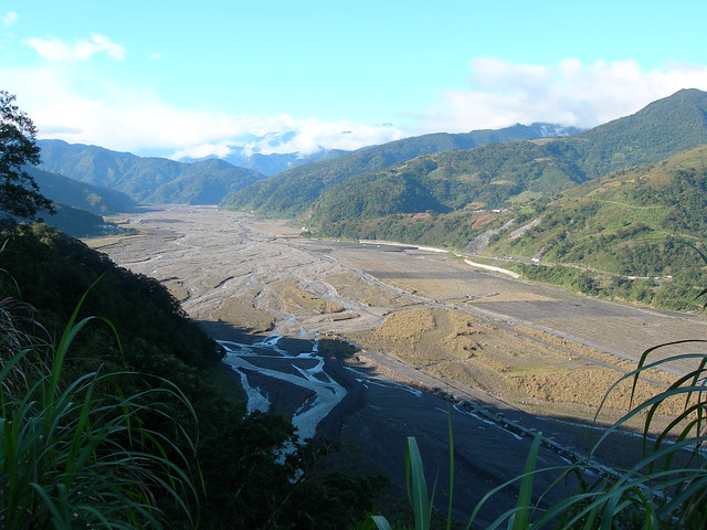
Down below is a massive riverbed which is actually mined for rocks in the dry season, which it is right now. You can see how small the actual river is. This is a clue about how massive the mountains are here. When the heavy rains come down on the hills and the water washes away on the way to the ocean, this will be full of raging water. This is a hint of what the rivers can do here when the big storms come:
Goodbye Hotel!
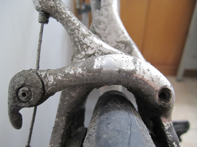
But not today. This day was full of awesome views and, again, slick roads. On the way up one of the hills my rear wheel spun out and slid a good 6 inches to 1 side. So even the shoulders of the well-traveled roads end up being slick as snot. When I got to the top of the climb today, I could actually see the green moss growing on the edge of the road. In some spots, there is a sort of constant landslide-wash dumping onto the road, which also makes it slippery. I have given up all notion of having a clean bike in this country. This is what my rear brake caliper looks like:
I got to the end of the climb for the day, which again was almost 2500 feet all told. This seems to be my magic number this week. I reached the base of TaiPing Mountain, which I think will be the first epic as it's only 34 miles from the apartment to the top. Of course, it's als0 over 6000 feet in the air so those last 10 miles may be a really tough slog. The other direction is Pear Mountain, which is a solid 65 mile ride but with the same vertical. Finally the cross-island highway splits off a bit further and goes up and over, no idea what that really entails. Climbing, I bet.
Unfortunately there's not a 7-11 out there, so water restocking may be an issue. I'll have to consult with the local guy and ask what the deal is with that. I can probably stuff 2 bottles in my jersey but it will be a bit of a force. I'd rather bring 2-3 and be able to stop somewhere. Even with 4, I'd probably spend the last 1-2 hours with no water. Thankfully it's almost literally 34 miles up, and 34 miles back down to end. I'm thinking 4.5-5 hours in total.
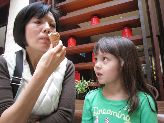
After I got back I was met by everyone leaving, and told by the FIL that we had a lunch date. In theory, I should be working so I needed to see how things were going. After a quick shower I hopped online with a pot of tea and saw that everything was quiet so I was able to join them. We were being treated by the guy who gave us that handmade glass dragon that we have hanging on the wall at home. They took us to the hotel where we had coffee yesterday. It was a high-end buffet place that most of the readers would have liked, I think. But Julia still objected and threw up when she saw the whole fish sitting on the table. She had no problem hawking mom's rum raisin ice cream though:
After lunch we drove to an Ilan museum which has a unique design best described by a picture. But since my set doesn't have any until the end, you'll need to wade through the next few paragraphs while we're inside. The basis of the museum is the cultural & ecological formation of the county as is stands today, from plants/animals to people to the ocean. It was pretty cool and much of it was available in English. I totally dig these high-level views so it was actually pretty cool. The design of the place, both inside and out, was awesome also.
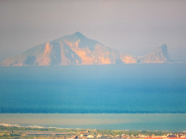
This is called Turtle Island and is in almost every picture you see of the landscape. Really, doesn't it look like a fish more than a turtle?
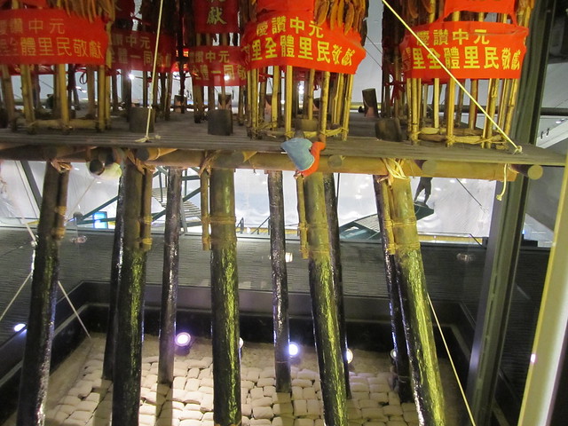
This is a model of the greased pole competition that the aborigines used to have. The poles would be like 50 feet high and loaded with grease. You had 5 guys to try and make it up. They would stand on top of each other's shoulders and the last guy would have to climb up the greased pole with only a rope to wrap around the pole to use as leverage. When he got to the top, he would then need to climb horizontally out away from the base and then up over that top level. Pretty cool model:
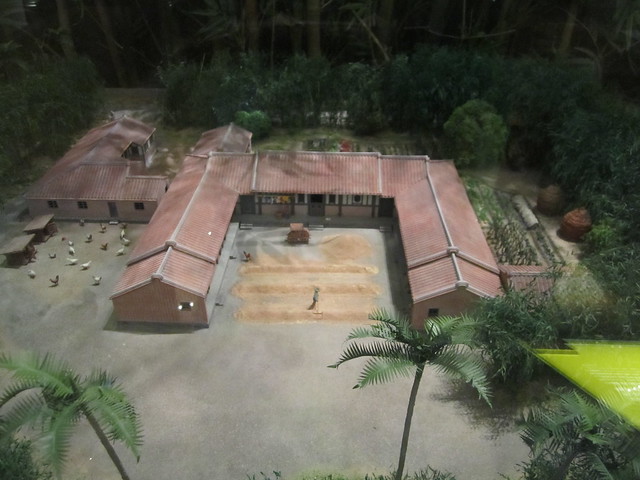
This is a model of an old-style family house complex. An entire family would live here, and my FIL actually grew up in something like this. The entire grounds was surrounded by bamboo to help when the typhoons would come. Rice paddys were outside the bamboo, and the middle courtyard was where grain was processed, or where the kids would play. Storage huts of a kind were on the outside:
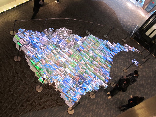
This was probably my favorite thing. It was a block model of the county, and the different elevation points had different numbers of blocks stacked up. he colors/images in the blocks would change so it almost appeared to be a sort of living entity. I love maps and stuff like this:
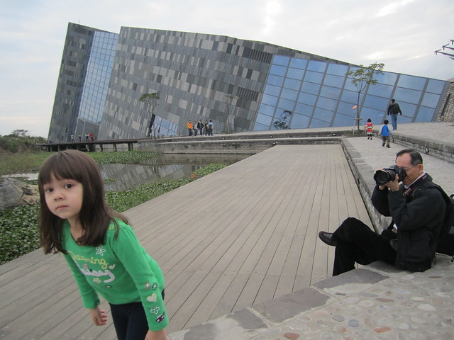
After a quick stop in the gift shop we took some pictures outside. Here you can see the shape of the building as well as how much Julia likes to cooperate with my FIL when he wants her to pose:
After a bunch of pictures we walked across the street to have a scallion pancake and a sort of dessert unique to the island. It's a pastry wrap filled with shaved peanut candy, cilantro, and taro ice cream. I love these and wish we could get a reasonable version in the states. The scallion pancake was a bit of a different style but had an egg in it and was loaded with scallions, then topped with a little hot sauce. Very good, even if it was different. Really hit the spot at the moment.
After that we went home and just had some noodles and veggies for dinner and put together some of the things we got at the museum for Julia, including a paper guy decked out in traditional Chinese garb and a balsa wood ferris wheel. And I had a Chimay, which was good but I think a bit long in the tooth.
2 firsts for today: A street cleaner (really? I never would have guessed) and a "real" road biker.
I've pretty much figured out my work groove. It goes something like this. Wake up early, work for a few hours and help out with the end of the day back on EST. Then go for a ride, come home, then work maybe 2 more hours and help the 2nd shift guy with any issues he's having. Then we do lunch and go out, run errands, do stuff, etc. If we're home I may hop online, or if I see emails when I'm out I'll reply. At the end of the day I'll throw in a few more hours unless I get them in during the day. I'm trying to cross-train this guy in London but he doesn't get in until 5:00 pm Taiwan time. So far, this has worked well. My PC in NY stopped responding to remote attempts but we got that worked out, mostly.
Told Nat I was going on a bit of a longer ride this morning, for no other reason than I want to start sprinkling in more time in the saddle so I can go out and explore more stuff. Most of the ride I had done before, but there was a bit of an extension at the end which I wanted to loop because it leads me to the base of 3 different epic rides I'd like to try to do before we leave - Pear Mountain, TaiPing Mountain, and the north cross-island highway. So it was a sort of scouting mission for those.
I preloaded breakfast and set out with the roads still wet from the rain overnight. The sun was supposed to show its face today but I was doubtful until I saw some blue sky in the distance, straight ahead. For the first 10 miles to the base of the hills, I was looking at a view straight out of a post card. Unfortunately I didn't have the good camera (I use the "old" digital to throw in my pocket) so the quality isn't really that great. But this gives you an idea:
Shortly after I headed off the main drag and onto an "industrial road" which is what a lot of these lesser roads are called. This one was well-paved and wide, so it wasn't a quarry road or anything like that. It went up quickly but not for very long, and it wasn't the leg-burner that the previous 2 days had been. I wanted today to be a tamer ride, so I scouted out a route with less vertical. No holy grail on this ride, at least not in theory. Imagine my surprise when I got to the top and saw this:
Down below is a massive riverbed which is actually mined for rocks in the dry season, which it is right now. You can see how small the actual river is. This is a clue about how massive the mountains are here. When the heavy rains come down on the hills and the water washes away on the way to the ocean, this will be full of raging water. This is a hint of what the rivers can do here when the big storms come:
Goodbye Hotel!
But not today. This day was full of awesome views and, again, slick roads. On the way up one of the hills my rear wheel spun out and slid a good 6 inches to 1 side. So even the shoulders of the well-traveled roads end up being slick as snot. When I got to the top of the climb today, I could actually see the green moss growing on the edge of the road. In some spots, there is a sort of constant landslide-wash dumping onto the road, which also makes it slippery. I have given up all notion of having a clean bike in this country. This is what my rear brake caliper looks like:
I got to the end of the climb for the day, which again was almost 2500 feet all told. This seems to be my magic number this week. I reached the base of TaiPing Mountain, which I think will be the first epic as it's only 34 miles from the apartment to the top. Of course, it's als0 over 6000 feet in the air so those last 10 miles may be a really tough slog. The other direction is Pear Mountain, which is a solid 65 mile ride but with the same vertical. Finally the cross-island highway splits off a bit further and goes up and over, no idea what that really entails. Climbing, I bet.
Unfortunately there's not a 7-11 out there, so water restocking may be an issue. I'll have to consult with the local guy and ask what the deal is with that. I can probably stuff 2 bottles in my jersey but it will be a bit of a force. I'd rather bring 2-3 and be able to stop somewhere. Even with 4, I'd probably spend the last 1-2 hours with no water. Thankfully it's almost literally 34 miles up, and 34 miles back down to end. I'm thinking 4.5-5 hours in total.
After I got back I was met by everyone leaving, and told by the FIL that we had a lunch date. In theory, I should be working so I needed to see how things were going. After a quick shower I hopped online with a pot of tea and saw that everything was quiet so I was able to join them. We were being treated by the guy who gave us that handmade glass dragon that we have hanging on the wall at home. They took us to the hotel where we had coffee yesterday. It was a high-end buffet place that most of the readers would have liked, I think. But Julia still objected and threw up when she saw the whole fish sitting on the table. She had no problem hawking mom's rum raisin ice cream though:
After lunch we drove to an Ilan museum which has a unique design best described by a picture. But since my set doesn't have any until the end, you'll need to wade through the next few paragraphs while we're inside. The basis of the museum is the cultural & ecological formation of the county as is stands today, from plants/animals to people to the ocean. It was pretty cool and much of it was available in English. I totally dig these high-level views so it was actually pretty cool. The design of the place, both inside and out, was awesome also.
This is called Turtle Island and is in almost every picture you see of the landscape. Really, doesn't it look like a fish more than a turtle?
This is a model of the greased pole competition that the aborigines used to have. The poles would be like 50 feet high and loaded with grease. You had 5 guys to try and make it up. They would stand on top of each other's shoulders and the last guy would have to climb up the greased pole with only a rope to wrap around the pole to use as leverage. When he got to the top, he would then need to climb horizontally out away from the base and then up over that top level. Pretty cool model:
This is a model of an old-style family house complex. An entire family would live here, and my FIL actually grew up in something like this. The entire grounds was surrounded by bamboo to help when the typhoons would come. Rice paddys were outside the bamboo, and the middle courtyard was where grain was processed, or where the kids would play. Storage huts of a kind were on the outside:
This was probably my favorite thing. It was a block model of the county, and the different elevation points had different numbers of blocks stacked up. he colors/images in the blocks would change so it almost appeared to be a sort of living entity. I love maps and stuff like this:
After a quick stop in the gift shop we took some pictures outside. Here you can see the shape of the building as well as how much Julia likes to cooperate with my FIL when he wants her to pose:
After a bunch of pictures we walked across the street to have a scallion pancake and a sort of dessert unique to the island. It's a pastry wrap filled with shaved peanut candy, cilantro, and taro ice cream. I love these and wish we could get a reasonable version in the states. The scallion pancake was a bit of a different style but had an egg in it and was loaded with scallions, then topped with a little hot sauce. Very good, even if it was different. Really hit the spot at the moment.
After that we went home and just had some noodles and veggies for dinner and put together some of the things we got at the museum for Julia, including a paper guy decked out in traditional Chinese garb and a balsa wood ferris wheel. And I had a Chimay, which was good but I think a bit long in the tooth.
2 firsts for today: A street cleaner (really? I never would have guessed) and a "real" road biker.
Labels: taiwan

0 Comments:
Post a Comment
<< Home